
The UAE has experienced rapid urban expansion and infrastructure growth over the past few decades. With towering skyscrapers, large-scale residential communities, and advanced transportation systems, the region demands precise planning before any construction begins. One crucial step in this process is a topographic survey. It provides critical data about land features, elevation changes, and natural and artificial structures, helping developers, architects, and engineers make informed decisions. This data is gathered by the professionals working at Topographic survey company in UAE for exact and informed results.
What Is a Topographic Survey?
A topographic survey is a detailed land assessment that records the natural and man-made features of a site, including terrain elevations, roads, buildings, utility lines, and vegetation. The data collected is used to create topographic maps, which serve as a foundational guide for construction, landscaping, and land development projects.
Key Components of a Topographic Survey
- Elevation Levels: Helps in identifying slopes and flat surfaces.
- Natural Features: Includes mountains, rivers, and trees.
- Existing Structures: Identifies buildings, roads, and pathways.
- Utility Lines: Highlights underground and overhead utilities.
- Boundary Lines: Ensures the legal limits of the property are clear.
Importance of Topographic Surveys in UAE Land Development
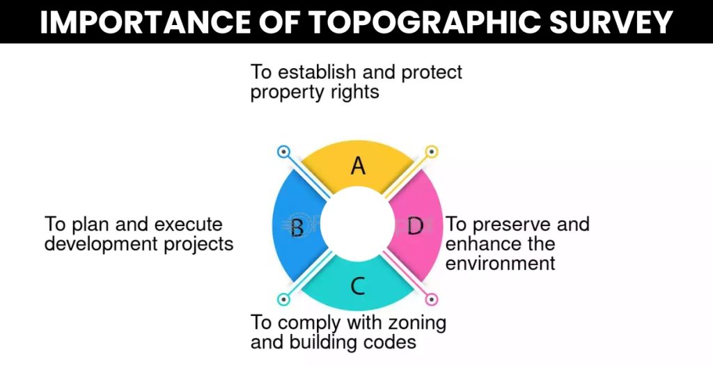
1. Ensuring Accurate Planning and Design
The UAE’s land varies significantly between desert landscapes and coastal regions. Understanding these variations is crucial for designing structures that fit the terrain. Accurate elevation data helps engineers and architects plan roads, drainage systems, and building foundations effectively.
2. Risk Mitigation and Safety
The UAE has strict construction and safety regulations. A topographic survey identifies potential risks such as flood-prone areas, unstable soil, or landfills that could impact construction. This information allows developers to take preventive measures and avoid costly future problems.
3. Regulatory Compliance
The UAE government mandates specific land assessments before any development project. A detailed topographic survey ensures compliance with regulations set by municipalities and authorities like the Dubai Municipality and Abu Dhabi Department of Urban Planning.
4. Cost-Effective Land Development
Investing in a topographic survey at the beginning of a project helps avoid unexpected expenses related to site preparation, excavation, and land grading. Developers can make informed decisions about whether the site requires additional work or modifications before construction begins.
5. Optimizing Land Use
A topographic survey helps developers maximize land usage by identifying the best areas for construction, roads, and green spaces. It also ensures efficient utilization of available space without disrupting existing ecosystems.
6. Improving Drainage and Flood Management
With some regions in the UAE prone to heavy rainfall and flooding, effective drainage systems are essential. Topographic surveys provide elevation data that help engineers design proper water flow channels, preventing water accumulation and soil erosion.
7. Supporting Infrastructure Development
The UAE continuously expands its infrastructure, including highways, bridges, and metro networks. A topographic survey in UAE ensures that these projects integrate seamlessly with existing landscapes, maintaining smooth connectivity and structural stability.
How Topographic Surveys Are Conducted
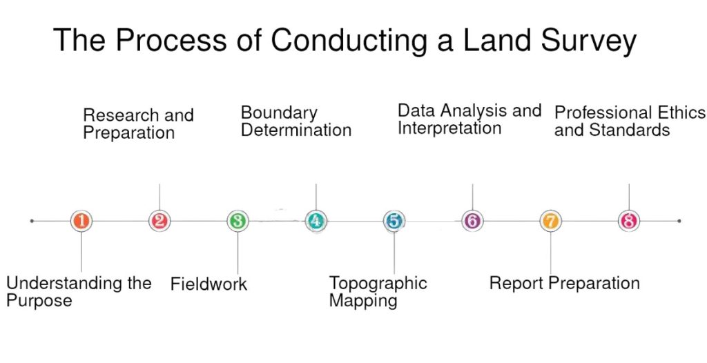
1. Data Collection Using Advanced Technology
Professional surveyors in the UAE use cutting-edge equipment, including:
- Total Stations: Measures horizontal and vertical angles.
- GPS Surveying: Provides high-precision location data.
- Drone Surveys: Offers aerial imaging for large-scale projects.
- LiDAR Scanning: Captures 3D terrain models.
2. Mapping and Analysis
After collecting field data, surveyors create detailed topographic maps and digital models. These maps are then used by architects, engineers, and government officials for planning and project approvals.
3. Final Reporting and Approval
Survey reports include site drawings, elevation details, boundary specifications, and risk assessments. These reports help stakeholders make well-informed decisions before breaking ground.
Industries Benefiting from Topographic Surveys in the UAE
1. Real Estate and Housing Developments
Builders use topographic surveys to ensure that new residential and commercial buildings are constructed on stable land, avoiding issues like uneven settlements or poor drainage.
2. Infrastructure Projects
Roads, bridges, and railway projects require precise land assessments to ensure smooth transportation networks across the UAE.
3. Oil and Gas Industry
The UAE’s oil and gas sector relies on topographic surveys for pipeline routing, drilling site selection, and environmental impact assessments.
4. Environmental and Landscaping Projects
For sustainable development, landscape designers and environmentalists use topographic surveys to preserve natural habitats, manage green spaces, and improve urban planning.
Choosing the Right Topographic Survey Company in the UAE
Selecting a reliable and experienced topographic survey company ensures that your land development project is based on accurate data. Here are some factors to consider:
- Licensed and Certified Professionals: Ensure the company has government-approved surveyors.
- Use of Advanced Technology: Check if they use GPS, drones, and LiDAR for precise data collection.
- Experience in UAE Regulations: The company should have expertise in local construction laws and zoning policies.
- Comprehensive Survey Reports: Choose a service provider that delivers detailed and easy-to-understand reports.
Conclusion
A topographic survey is an essential step in land development across the UAE. It helps in accurate planning, reduces risks, ensures compliance with local laws, and optimizes land use. Whether you are working on real estate projects, infrastructure development, or environmental conservation, investing in a high-quality topographic survey ensures that your project is built on solid ground. By choosing the right survey company, developers can make informed decisions, save costs, and contribute to the UAE’s growing landscape responsibly. By choosing the right survey company, such as Arabainse.com, developers can make informed decisions, save costs, and contribute to the UAE’s growing landscape responsibly.